 When I was a kid, we made an annual summer trek across the country in the family station wagon to visit family. My dad would order his AAA maps for each trip and they would come with our route neatly highlighted in marker. To pass the time I liked to follow our progress, but after the bazillionth “Where are we now Dad?†he figured it was time to come up with some way to keep me busy. He saved the maps from previous trips so I could happily track our progress on my own map. I guess that’s where my love of maps began.
At genealogical conferences, my first shopping stop is the closest booth that has historical maps. Another favorite pastime of mine is to browse huge collections of historical maps online. Ancestry.com recently updated its Historic Land Ownership and Reference Atlases, 1507-2000. I had a little time to kill last night, so I thought I would take a look at what was available.
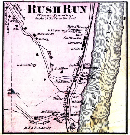
A neat find was a map of Rush Run, Ohio from 1871. (Click on the image to enlarge it.) My grandfather was born there in 1906 and even though the map was from thirty years prior, it was still really interesting. I had never realized the town was actually on the banks of the Ohio River. Mapquest makes it appear a bit further from the river. It also noted coal veins in the area, which is very relevant to my family history because my great-grandparents’ families were miners and they ran the mining store.Â
The Cleveland and & Pittsburgh Railroad line is shown with a stop in Rush Run. Since my great-grandparents moved back and forth to and from Cleveland and the southeastern Ohio area around Rush Run, I imagine that could have been a convenient way to get back and forth. For many trains were the easiest way to travel, so pay close attention to the railroads in the areas in which your ancestor lived.
The maps are really detailed and if you find one for a place in which your ancestor lived, you may find his name on the map as the property owner. This particular map showed the location of the coal mine shaft and the coke ovens too.Â
Finding the Map
You can search the database by keyword, which I’ve found to be more effective than searching by location, or you can browse by state, which is what I prefer to do. Some of the maps are listed by county, while others may focus on only a city. I found quite a few “bird’s eye views†as I explored the collection.
When you scroll down past the search box to the browsable links, you’ll notice that there are also several Canadian provinces listed among the states. I found a really neat map of Quebec from 1764.
Another link is to Other Maps and here I found among others a map of Dublin from 1895.
If you haven’t checked this collection in a while, give it another look. And while you’re at it, the U.S. County Land Ownership Atlases, c. 1864-1918 is very similar and has maps from states not included in former. .
Juliana Smith has been an editor of Ancestry newsletters for ten years and is author of “The Ancestry Family Historian’s Address Book.” She has written for “Ancestry” magazine and wrote the Computers and Technology chapter in “The Source: A Guidebook to American Genealogy,” rev. 3rd edition. Juliana can be reached by e- mail at [email protected], but she regrets that her schedule does not allow her to assist with personal research.

Juliana,
Perhaps the town of Rush Run was moved from the banks of the Ohio River after 1871 because of flooding, dam construction or fire. Or maybe the commerce area of the unincorporated town shifted the half a mile or so west after 1871 because of business competition. Maybe there are old-timers still living in the area who could provide information.
Another place I’ve found historical and physical information about the small rural town and area where I was born and raised is from old Forest Service, or other government ecology type departments (DNR, BLM, etc.) reports, maps and surveys. Also, I’ve found some in old documents (public information) that were discarded by government agencies. Dumpster diving can be useful if you know when and where to look…or have inside sources. It would probably help to make sure it’s okay with the dumpers before diving. You wouldn’t want your name on police records for stealing government property. There’s so much information that has been lost because the caretakers of those documents no longer wanted or needed it. It helps to get to know your city clerks and let them know that you are interested in past documents, maps or whatever. Of course, that works better with smaller towns. Check at local Forest Service offices and other government agencies. City halls and county courthouses aren’t the only government offices with helpful documents. And would the railroad have old info to share?
Nadine (another enthusiast of old maps)
Pingback: Historic Land Ownership and Reference Atlases « Genealogy Blog Linker